Maps & Location
Helena and Aurora Range, Bungalbin is located about 100 km north-east of Southern Cross and 50 km north-east of Koolyanobbing. Travel wise, Helena and Aurora Range is 2 hours drive north of Southern Cross and 6 to 7 hours drive east of Perth.
People refer to Helena and Aurora Range, Bungalbin as being located;
- within the Shire of Yilgarn,
- in the Coolgardie Bioregion or Region (part of the IBRA, Interim Biogeographic Regionalisation of Australia, where regions are based on their vegetation and geology),
- in the Southern Cross Subregion within the Coolgardie Region of the IBRA
- in the South-West Interzone (Beard 1979) located between the Ermaean and South West Provinces (Beard's Botanical Provinces),
- known as a "transitional rainfall and vegetation zone between the Southwest and Eremaean Botanical Provinces and so corresponds to the limits of distribution of many plants and plant communities in the goldfields and wheatbelt" (EPA, 2007).
- situated on the Yilgarn Craton, or in the Northern Yilgarn (close to the centre of the Yilgarn Craton or within the northern half of the Yilgarn Craton),
- in the Parks and Wildlife Service Goldfields Region (Department of Biodiversity, Conservation and Attractions*) or Eastern Goldfields, and
- within the Great Western Woodlands of Western Australia.
As such Helena and Aurora Range, Bungalbin is in a very special part of Western Australia that is near pristine, is remote, yet not so far from Perth. Within the conservation estate of Western Australia, Helena and Aurora Range is one of the Conservation Parks included within the Northern Yilgarn (Mt Manning Range, Mt Elvire and Jaurdi) Conservation Reserve (see Conservation Maps). Or more simply, in earlier times, was part of the Mt Manning Reserve system.
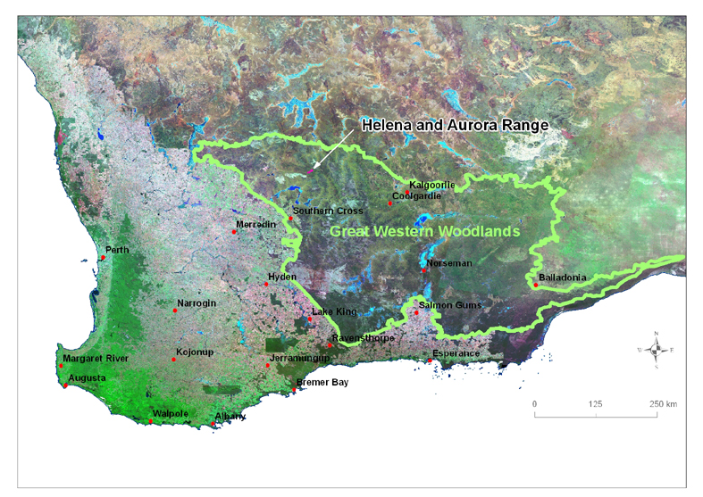
Helena and Aurora Range, Bungalbin within the Great Western Woodlands of Western Australia (image: courtesy of Amanda Keesing, Gondwana Link)
A closer look as to where Helena and Aurora Range, Bungalbin is located
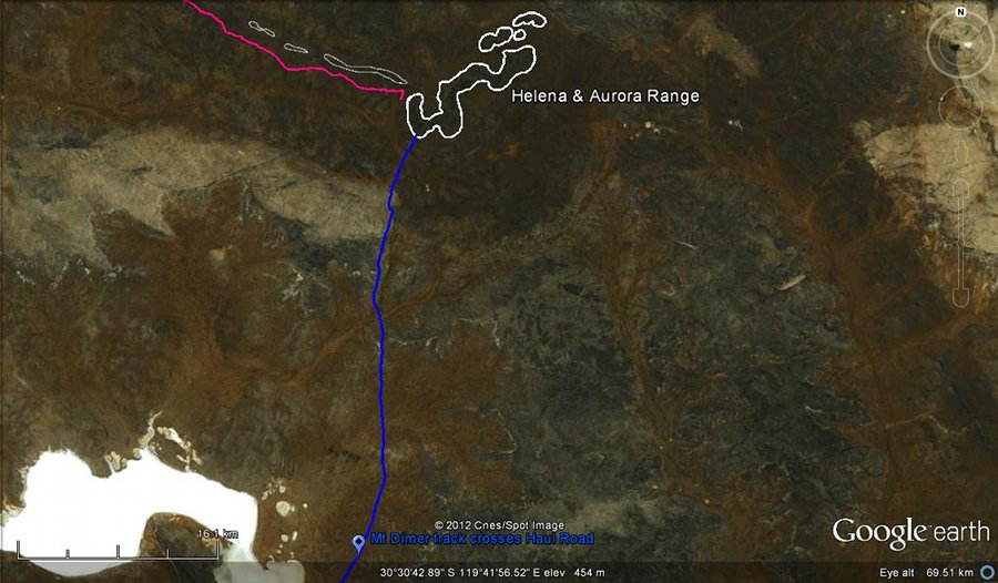
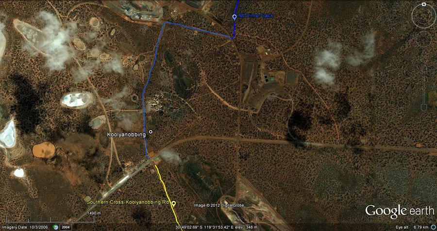
The four maps below, developed using Google Earth, are to give a broad view of where Helena and Aurora Range, bungalbin is in respect to main tracks, other ranges and Koolyanobbing. Please use maps in a travellers atlas or topographic maps available from map stores (1:250,000 or 1:100,000) to navigate your way to Helena and Aurora Range, Bungalbin. The most direct route to Helena and Aurora Range, Bungalbin is from the Great Eastern Highway then via Southern Cross and Koolyanobbing. A detailed map of the route via Koolyanobbing is provided below these four Google Earth maps.
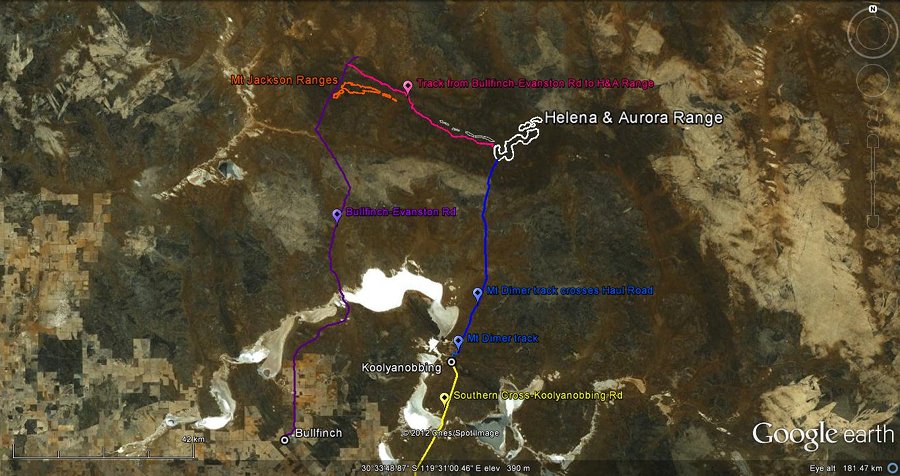
Below are three maps zooming in to the above Google map and showing more details
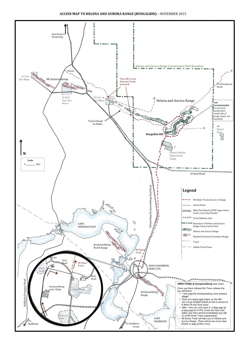
Access Map and Directions
1. Directions for accessing Helena and Aurora Range, Bungalbin via Koolyanobbing:
From Perth to Southern Cross it is approximately 4 hours drive on Great Eastern Highway.
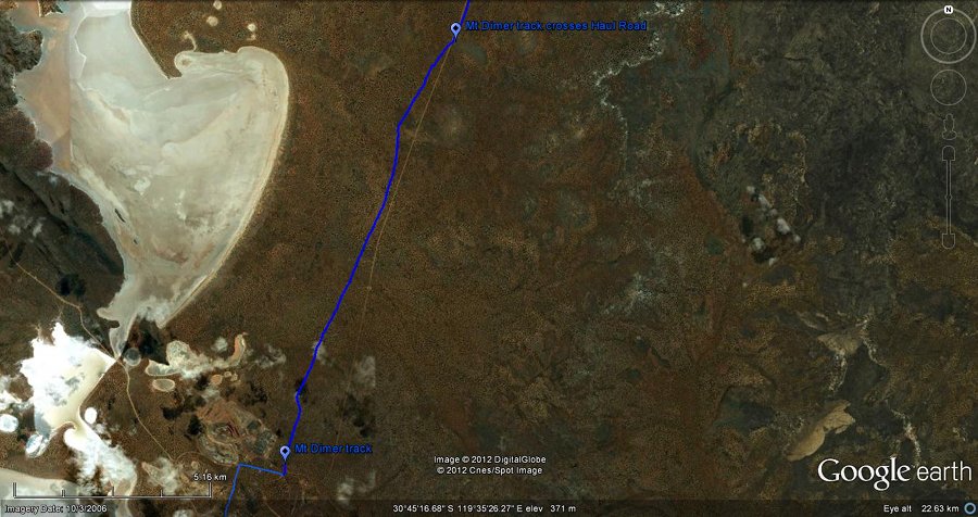
From Southern Cross to Koolyanobbing (active mine site) it is about ~50 km, 45 min.
From Koolyanobbing to Helena and Aurora Range it is about ~60 km, 1 hr.
At Koolyanobbing you travel ~1 km past the Koolyanobbing 'workers village' towards K Pit, turning sharp right before the pit (is the first right turn available after the main entrance to the workers village). After another ~1 km you will come to a Stop sign at a haul road (to K Pit); Cross the haul road and then almost immediately there will be a track on your left saying To Mt Dimer. Take this track as it will take you to Helena and Aurora Range.
The track to Mt Dimer crosses the Koolyanobbing-Windarling Haul Road (with Stop sign); once crossed the track follows parallel to the Haul Road for a while until the Haul Road eventually veers away to the west.
The track will then take you to another Stop sign at the J4 Haul Road (built in 2015). Once you have crossed this second haul road on the Mt Dimer Track you will continue north along the track and enter the Helena and Aurora Range Conservation Park (Park sign on your left).
You will then pass through a junction with signs saying Aurora Exploration camp at a track to the right, contunue on straight ahead on to a two wheel track, until you come to a T junction at the base of Bungalbin Hill. This ia at the range's south-western end.
At the T junction, turn left (~north) to take you along the west side of the range and give you access to the track that goes to the top of the range. If you turn right at the T junction the track will take you along the eastern side of the range and give you access to the Mt Dimer Track (heads out east and then north).
Please be careful crossing the Haul Roads and give the Dump Trucks and Haul Trucks lots of space (eg. let them go past before you cross).
An Access Map (pdf) is provided below and is downloadable (formatted to A3 size)
2. Directions for accessing Helena and Aurora Range, Bungalbin via the Bullfinch-Evanston Road:
This is a longer route than via Koolyanobbing. If you have the time and want to explore more country it is worthwhile.
For those that have been this way before, Mineral Resources Ltd have made a detour around the J4 mine (now closed), located at the very north-west end of the low hills of Helena and Aurora Range. This was done so that people could still access Helena and Aurora Range from the Bullfinch-Evanston Road. The access map (jpg) indicates the Haul Roads and changes to tracks.
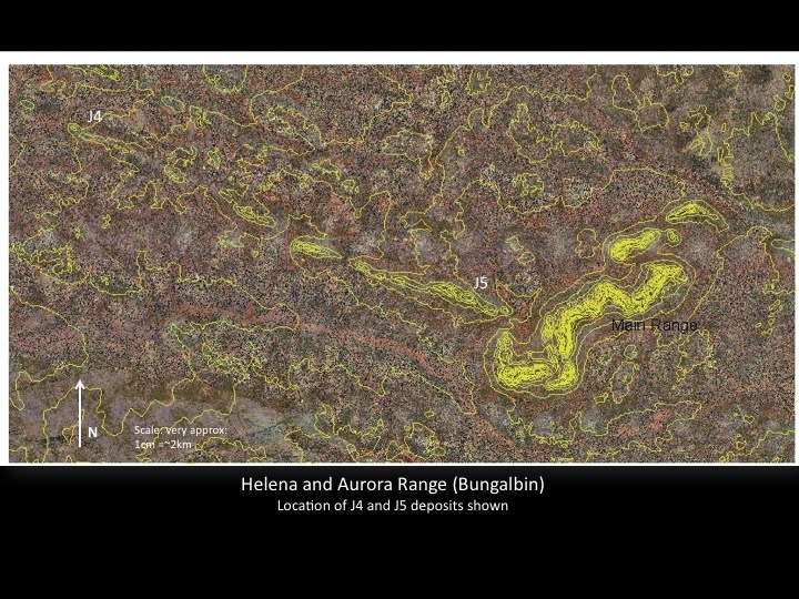
Map of Helena and Aurora Range, Bungalbin
Helena and Aurora Range, Bungalbin includes the main range, a group of convoluted tall BIF ranges lying in a north-east direction, and a more or less straight length of low BIF ranges lying in a north-west direction, starting north of the south end of the main range and finishing near the east end of the Mt Jackson Range. The low BIF hills include iron ore deposits referred to as J5 and J4 (mined). These hills are intrinsically linked (not just by name) as they support the same vegetation type, open Eucalyptus over Neurachne annularis grasslands, and feed in to the same watercourses.
A map of the full extent of Helena and Aurora Range, shown with aerial photography and contours. The location of J4 iron ore deposit/mine and J5 iron ore deposit are also indicated.
Contour map of the main range of Helena and Aurora, Bungalbin
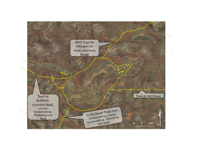
A contour map of the main range of Helena and Aurora Range, Bungalbin with tracks set on aerial photography has been put together for us by Amanda Keesing. The aerial photography was purchased from Landgate. The main range lies in a north-east direction. We have presented this beautiful map firstly with no explanatory text, then as two maps with explanatory notes.
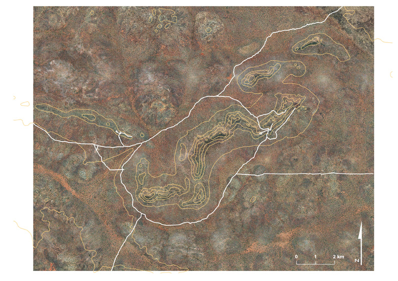
Helena and Aurora Range showing contours and tracks on aerial photography (purchased from Landgate) (GIS work by Amanda Keesing).
Access tracks to and from Helena and Aurora Range, Bungalbin
There are four tracks going in to (and out of) Helena and Aurora Range.
- Mt Dimer Track - entres from the south, starting at Koolyanobbing and arrives at the Base of Bungalbin Hill on Helena and Aurora Range. It travels around the east side of the Range.
- Mt Dimer Track - exits heading directly east of the Range. There are many tracks out towards Mt Dimer, Mt Dimer mine (currently closed though occasionally active from time to time) and Mt Finnerty Range.
- North-West Track - a track that heads out to the north-west from the south end of the Range. This track travels past J5 iron ore deposit, detours around J4 iron ore mine, to eventually cross Windarling-Koolyanobbing Haul Road, it then passes by Marda Dam and then on to the Bullfinch-Evanston Road.
-
North-East Track - a track that continues north-east, past the turn off in to the Range (on the north side), to arrive at Pittosporum Rock, Kurrajong Rock and Hunt Range. This track joins other tracks to Mt Manning, Menzies, Mt Finnerty and Jaurdi Station.
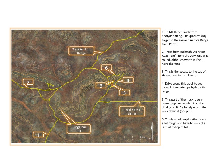
More information on Notes 1-6 on contour map:
Note 1. This is on the track 'To Mt Dimer' and is where you would come in to Helena and Aurora Range if coming from Koolyanobbing (via Southern Cross). This is the quickest way to get to Helena and Aurora Range from Perth (a total of 6 to 7 hours). To get to this track you cross a mine haul road near Koolyanobbing and once on this track you cross the Koolyanobbing-Windarling Haul Road. Detailed directions are given below.
Note 2. This is where you would come in if coming in from the Bullfinch-Evanston Road (via Southern Cross and Bullfinch) or if you want to head out to Bullfinch-Evanston Road. Definitely the very long way round, though worth the trip if you have the time. This track heads out on the south side of the long low BIF ranges of Helena and Aurora Range that lie in a north west direction and include deposits referred to as J5 and J4. This track crosses the Koolyanobbing-Windarling Haul Road, and passes Marda Dam before meeting Bullfinch-Evanston Road.
Note 3. This is the top of Helena and Aurora Range where you can drive to. It is flat topped. Definitely a must go and see, beautiful views and more. While most people tend to camp on the flats near the range, some seem to camp up here too - however may be a bit difficult for toilet areas if staying a while. There are many good camp sites on the flats, particularly among the open woodlands.
Note 4. This track is less formed than the others (not marked on maps). Can walk on past where track ends to see some specky White gums close up (Eucalyptus capillosa). Also as you drive along track you can see some awesome caves in the outcrops high on the range.
Note 5. Track marked in red. This part of the track is very very steep to go down - probably best not to. Is really worth walking down though (or up) - and just a short walk to some beautiful outcrops. This is where the Eastern Ore deposit is located for mining Iron Ore.
Note 6. This track is an old exploration track and difficult to traverse towards the top. You will need to walk the last section to get to the top of the ridge.
Track to Mt Dimer. Heading east then north to the Mt Dimer Mine and Hunt Range.
Track to Hunt Range. This is indicated as a 4WD Track only in the Travellers Atlas. This track will take you to Pittosporum Rocks and Hunt Range.
Note:
*Department of Biodiversity, Conservation and Attractions (DBCA) was formed on 1 July 2017 and brought together the Department of Parks and Wildlife, Botanical Gardens and Parks Authority, Zoolgical Parks Authority and Rottnest Island Authority. Department of Parks and Wildlife is now Parks and Wildlife Service. Prior to this, on 1 July 2013, DEC (Depatment of Environment and Conservation) was separated into two departments; Department of Parks and Wildlife (DPaW) and Department of Environment Regulation (DER).
References
Environmental Protection Authority (2007) Advice on areas of the highest conservation value in the proposed extensions to Mount Manning Nature Reserve. Advice of the Environmental Protection Authority to the Minister for the Environment under Section 16(e) of the Environmental Protection Act 1986. Bulletin 1256, May 2007, Perth, Western Australia (pg. iii).